Geospatial AI for Climate Risk Identification
Introduction to Geospatial AI in Climate Risk Assessment
Understanding the Role of Geospatial Data
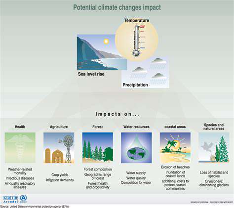
When assessing climate risks, location-based information such as coordinates, elevation, and visual data forms the backbone of modern analysis. Integrating these elements with artificial intelligence transforms how we predict and manage climate threats, enabling models that account for historical weather trends, shifting land use, and population distribution. Such granular analysis pinpoints vulnerabilities, guiding where to focus resilience efforts.
The depth of spatial datasets proves indispensable. Satellite snapshots exposing forest loss or topographic charts marking flood zones offer the raw material for thorough risk evaluations. Without current, precise geospatial inputs, any mitigation strategy risks being dangerously outdated - like using yesterday's weather map to plan tomorrow's evacuation routes.
Utilizing AI for Predictive Modeling
Machine learning algorithms excel at teasing out hidden connections within complex spatial datasets, spotting climate hazard patterns that conventional methods overlook. These systems forecast extreme events - from cyclones to water shortages - while calculating potential damage to roads, power grids, and communities. What sets AI apart is its ability to learn continually, refining predictions as fresh data streams in.
Trained on decades of climate records paired with geographical data, these models project future dangers with startling locality. A coastal city receives flood predictions accounting for its unique shoreline shape, while farming regions get drought alerts calibrated to their soil types. This specificity enables defenses as unique as the threats themselves.
Mapping and Visualizing Climate Risks
Spatial AI crafts dynamic maps that translate intricate climate data into clear visual stories. These aren't just colorful charts - they're decision-making tools showing precisely where floodwaters might crest or which neighborhoods face the highest heat risks. When mayors see their city's vulnerabilities layered over school and hospital locations, infrastructure priorities become obvious.
The real power emerges when datasets intersect - a flood risk layer combined with elderly population density reveals which communities need evacuation assistance most urgently. Such visual tools democratize climate knowledge, letting everyone from engineers to homeowners understand their personal risk landscape.
Developing Climate Resilience Strategies
Geospatial intelligence transforms climate planning from guesswork to precision. Cities can now allocate stormwater upgrades block-by-block or position emergency supplies where they're statistically most needed. This data-driven approach prevents wasted resources - why build a sea wall where elevation data shows minimal risk? Farmers consult crop viability maps that account for shifting rainfall patterns, planting drought-resistant strains exactly where they'll thrive.
The method's beauty lies in its adaptability. As climate patterns shift, the models recalibrate, ensuring preparedness efforts evolve alongside emerging threats. Coastal towns might initially focus on hurricane defenses, then pivot to address rising saltwater intrusion as AI detects new groundwater trends.
Integration with Other Disciplines
Geospatial AI reaches full potential when married with socioeconomic insights. Overlaying flood maps with income data exposes which vulnerable populations lack resources to relocate. This prevents climate policies that inadvertently protect wealthy neighborhoods while leaving marginalized communities at risk - a critical consideration for equitable resilience planning.
Fusing environmental models creates an even richer tapestry. Hydrological data shows how melting glaciers might affect downstream agriculture, while ecological models predict how species migration could destabilize local food chains. This systems-thinking approach mirrors nature's interconnectedness, yielding climate strategies as complex and nuanced as the challenges we face.

Read more about Geospatial AI for Climate Risk Identification


Hot Recommendations
- AI in Property Marketing: Virtual Tours and VR
- Water Management Solutions for Sustainable Real Estate
- IoT Solutions for Smart Building Energy Management
- Sustainable Real Estate: Building a Greener Tomorrow
- Sustainable Real Estate: From Concept to Community
- AI Driven Due Diligence for Large Scale Developments
- Real Estate Sector and Global Climate Agreements
- Smart Buildings: The Key to Smarter Property Management
- Zero Waste Buildings: A Sustainable Real Estate Goal
- Understanding Climate Risk in Real Estate Financing